

We have been calling them "winter" storms, but perhaps to be more technical we should have called them "fall" storms. The winter solstice does not officially begin for a little over a week, but already we have had two winter storms sweep across the state in the past couple of weeks, the second certainly the more drastic of the two. These storms have been caused by exceptionally strong cold fronts, fueling arctic air from the north, along with upper-level lows, which have provided moisture in the air to support the wintry precipitation. When forecasting winter weather, cold air and moisture are two of the primary aspects that meteorologists look at. If either aspect varies just slightly, a forecast could change dramatically. We will now take a step back in time and examine the two winter storms of the past weeks in depth.
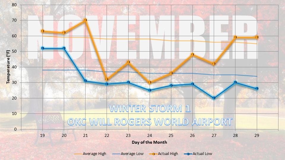 The first winter storm occurred prior to Thanksgiving, from Friday, November 22 through Sunday, November 24. What was a relatively warm state for about a week up until that time suddenly changed as the strong cold front pushed through Thursday morning through evening. In fact, take a look at the drastic temperature drop at Oklahoma City's Will Rogers World Airport from the 21st to 22nd of the month. A 70-degree high on Thursday gave way to a 32-degree high on Friday, which was recorded close to midnight as temperatures continued to fall throughout the day. As the cold air arrived, the moisture was not yet in place. Thus, areas of Oklahoma, particularly central and northern Oklahoma, which were forecasted to see showers and thunderstorms ahead of the cold front saw little to no precipitation - perhaps a light drizzle at best. As the front pushed southward throughout the day, thunderstorms finally began to develop, so areas of southern Oklahoma and certainly north Texas saw some rainfall towards the evening.
 |
| Rain, Freezing Rain, Sleet, Snow…What’s the Difference? Provided by EarthGauge |
 The freezing rain left a decent glaze of ice up to .25 inches on surfaces across parts of central and eastern Oklahoma. These areas also received a little bit of sleet at times, also creating icy conditions. As the temperature rose above freezing on Saturday, the icy surfaces had the chance to melt. However, a second round of wintry weather occurred Saturday night into Sunday, bringing more frozen precipitation to parts of the state. With the second round, southwest Oklahoma got hit hardest, with areas of 10+ inches of snow! The snow became less impressive as it tracked northeastward, due to the lack of moisture in the air. The air was cold enough, but the air was so dry, especially in central Oklahoma, that much of the snow evaporated before reaching the ground. However, areas in and around the Oklahoma City metro area still managed to pick up near an inch of snow and sleet. You can see a map of select snowfall totals provided by the National Weather Service in Norman, OK to the right.
Following the first storm, temperatures were on a steady rise through the Thanksgiving holiday and into the early part of the following week. Then, Mother Nature decided to blast Oklahoma with another round of winter weather, which came in two waves. The strong cold front came through Tuesday night and into Wednesday, ushering in cooler air with it. However, the exceptionally cold air did not arrive until several hours after the cold front passed through. Additionally, the moisture would not be in place until Wednesday night through Thursday. The arrival of the cold air at least 24 hours prior to the moisture would be the perfect setup for a significant winter storm, as the cold air has a chance to "settle" before precipitation begins to fall.
 Precipitation began to fall in the middle of the morning on Thursday, with the primary precipitation type being freezing rain in southern Oklahoma and sleet and snow across central and northern Oklahoma. The freezing rain-sleet/snow transition line was positioned in the middle of the state, across the southern part of the Oklahoma City metro area, causing more of a freezing rain and sleet mix in areas such as Norman and Moore. However, in the northern part of the metro, areas such as Edmond saw a few inches of snow throughout the afternoon. The first round of winter weather ended by the late evening across central Oklahoma, though the freezing rain moved off to the south and east and continued to pound southern Oklahoma through the overnight hours, as well as parts of northeast Oklahoma early. The second round of winter weather originated across west Texas and pushed north-northeastward into the state. With the air continuing to cool and enough moisture provided, this round of winter weather was primarily snow, along with very little sleet mixed in. The snow band grew and intensified as it pushed towards the north, bringing southwestern Oklahoma through northeastern Oklahoma a steady snow that fell through the night from Thursday through Friday morning. Snow totals varied across the state, but heavier snow bands brought up to 6 inches around the Fort Cobb area. The snowfall/sleet totals from the December 5-6 winter storm are at the left.
 As the precipitation exited the state by Friday morning, the cold temperatures did not. Due to an arctic high that settled in, temperatures remained well-below freezing for several days. Across the Oklahoma City metro area, temperatures stayed below freezing for a little over 135 hours - that's 5 days and 15 hours! Not only that, but lows both Friday night and Monday night were exceptionally cold across the state, dropping down into the single-digits (and even the negatives) for many. You can see the temperature drop recorded at Oklahoma City's Will Rogers Airport for the duration of the second winter storm to the left. Note how the temperature drop is more steady than that from a couple of weeks ago.
Due to the frigid temperatures, ice and snow have remained on the ground across the state for a good part of the week. In fact, some areas are still seeing traces of snow on the ground that are slowly melting as temperatures rise above freezing. So what lies ahead? Please be cautious of a very slight chance for freezing rain tonight. No accumulation is expected, as the rain will be brief and light. Additionally, temperatures will either be right at or a degree above freezing. Rain is expected tomorrow, but with highs reaching the 40s, frozen precipitation will not be a problem. The next swath of exceptionally cold weather is expected to come late next week. This could bring a week of cold temperatures, with highs in the 30s and lows in the teens. Winter weather is not yet a possibility, but this could change. Details are not completely known and will be gathered as more information becomes available.
Thanks for reading! To those of you involved with final exams this week, we wish you the best of luck and hope you have done well. Have a wonderful holiday season!
AC
Sources: NWS, SPC, Mesonet, Google Images (story photo)
No comments:
Post a Comment