

Expect another day of hot temperatures all across Oklahoma as the heat wave continues. High temperatures will be in the mid-90s to low-100s, but high humidity levels, especially in central and eastern Oklahoma, will lead to heat indices reaching the 110-degree mark. Currently, we have a HEAT ADVISORY in effect for counties in eastern and north central Oklahoma through 9 PM CDT this evening. An EXCESSIVE HEAT WARNING remains in effect for Tulsa county until 8 PM CDT this evening. We strongly urge you to avoid outdoor activities today. If you must be outside, remember your heat safety tips, which are listed on a graphic below, courtesy of the National Weather Service office in Norman, OK.
Heat Safety Tips

Graphicasts


Special Story
 Right on time! The mercury at Oklahoma City's Will Rogers World Airport reached 100 degrees yesterday afternoon. This marks Oklahoma City's first 100-degree day of the year, which is exactly the average date of seeing the year's first triple-digit day: July 9. What may be a little shocking is that only a month ago, June 10 to be exact, Oklahoma City's first 90-degree day of the year was recorded. Thus, it seems as though the cooler-than-average spring will have no affect on ongoing summer. Another day of triple-digits is expected for Oklahoma City and a great deal of the state this afternoon. See the Detailed Forecast below for more information.
Detailed Forecast
 For this afternoon, expect the warmest highs to occur across the core of the state, mainly in central Oklahoma and parts of western and eastern Oklahoma, where the low-100s are being forecast. The panhandle and northeast will actually see slightly "cooler" temperatures in the mid-90s today. South central and southeast Oklahoma will see highs in the upper-90s. However, do not let any lower highs fool you. Humid conditions will lead to dangerously high heat indices. Across central and eastern Oklahoma, heat index values will be between 105 and 110 degrees, with the higher heat indices being in north central and eastern Oklahoma, prompting the heat advisory and excessive heat warning.
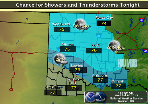
Currently, we have a surface low that is positioned in south central Kansas near the Oklahoma-Kansas border. To the east of this surface low is a cold front that is accounting for the slightly cooler high temperatures in northeast Oklahoma today. To the west of the surface low is a stationary front. These fronts will move towards the south, and as a result, isolated strong thunderstorms are possible later this afternoon across northern Oklahoma, north of Interstate-40. This includes the panhandle. Gusty winds and brief downpours are possible with developing storms, so keep an eye on the sky this afternoon. Later this evening and tonight, all of the state, with the exception of the extreme southwest, has the potential of seeing a chance for showers and thunderstorms. See the graphicasts above for more information.
On Thursday, expect morning lows in the low-to-mid-70s across the state. In the afternoon, highs in the panhandle rebound to the low-100s. Highs across the south, well south of Interstate-40, will continue to stay warm in the upper-90s to low-100s. Farther towards the north, the cold front will bring a slight relief from the heat with highs in the low-to-mid-90s. A chance for afternoon thunderstorms exists across all of the state Thursday afternoon and Thursday evening. Otherwise, skies will be mainly sunny with a few scattered clouds.
For Friday, morning lows will again be in the low-to-mid-70s across the state. Afternoon highs will soar in the west, reaching the low-to-mid-100s. Across central and eastern Oklahoma, the highs should remain in the mid-to-upper-90s. Skies will be mainly sunny, with a few afternoon clouds. No thunderstorms are expected on Friday.
Sources: NWS, HOOT, tucsonsentinel.com (photo)
No comments:
Post a Comment