

The weather today will be everything but the kitchen sink (and snow). Ahead of a cold front approaching the state from the north, we will be dealing with intense summertime heat, with this afternoon’s temperatures soaring well into the upper-90s to upper-100s. Then this evening and into tonight, we are looking at the chance for severe weather across northern Oklahoma and parts of central Oklahoma as the cold front pushes through. By the weekend and into next week, we will see a long stretch with temperatures that are significantly cooler and even below average in some cases. However, before that time, we will have to deal with this scorcher. Note that the following heat alerts are in effect:
EXCESSIVE HEAT WARNINGS until 7 PM CDT Friday for most of eastern Oklahoma
HEAT ADVISORIES until 8 PM CDT Thursday for all of central and western Oklahoma (excluding the panhandle)


Today
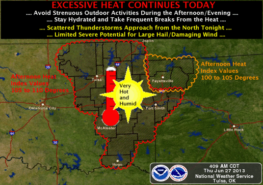
 Skies in the afternoon will be mainly sunny, but in the early to mid-afternoon we may see a few thunderstorms pop up in northwest Oklahoma. High temperatures will be warmest across southwest Oklahoma today, reaching the upper-100s. The rest of western Oklahoma will see highs in the low-to-mid-100s. For central and eastern Oklahoma, we will see highs topping out in the upper-90s to low-100s. Heat indices will be highest and most dangerous in eastern and north central Oklahoma, reaching anywhere between 105 to 115 degrees. In central and western Oklahoma, heat indices will be around 105 degrees. A south to southwest wind will blow between 5 to 10 mph this afternoon, providing little relief from the heat. We strongly urge you to avoid all outdoor activity this afternoon! If being outdoors in unavoidable, please remember your heat safety tips.
This Evening/Tonight
 Due to very humid conditions, intense afternoon surface heating, and an approaching cold front, the atmosphere will be unstable later this evening, supporting the development of severe thunderstorms along the cold front approaching from the north. The Storm Prediction Center has issued a SLIGHT RISK for all of northern Oklahoma and central Oklahoma, just north of the Oklahoma City area. A line of storms developing along the cold front will move south from Kansas into Oklahoma, forming a squall line. These storms will primarily affect all of northern Oklahoma, from 6 pm this evening to midnight Friday. However, before the squall line weakens as it moves south, a few severe thunderstorms are also possible across central Oklahoma from 8 pm this evening through 2 am Friday. Primary threats from these storms will be damaging winds in excess of 70 mph, large hail to golf ball size, and locally heavy rainfall over 1 inch. The tornado threat is low, but we cannot rule one out. The best chance of a tornado would be in extreme north central Oklahoma this evening.
Friday
Any overnight thunderstorms will linger across central and southern Oklahoma Friday morning. Lows will be in the upper-60s across the panhandle and in the low-to-mid-70s elsewhere across the state. Skies in the afternoon will be mainly sunny, with temperatures still remaining warm in some places while “cooling off” in others. In southwest Oklahoma, highs will still be in the low-to-mid-100s. For the rest of western Oklahoma, however, we should see highs in the mid-to-upper-90s. This will also be the case for central and eastern Oklahoma. Continuing humid conditions will lead to heat indices reaching between 100 and 105 degrees across central and eastern Oklahoma. Variable winds in the morning will become northerly in the afternoon. Speeds will also vary, with the strongest being in central Oklahoma at 15 to 20 mph in the afternoon. Elsewhere we will see sustained wind speeds between 5 and 15 mph.
Sources: NWS, SPC, HOOT
No comments:
Post a Comment