

The beautiful fall weather Oklahoma experienced this past weekend will be coming to an end tonight and tomorrow. In its place will be a strong arctic air mass behind a powerful cold front that is currently sweeping southward into the state. This cold air will be the coldest Oklahoma has experienced this season, so please plan accordingly.

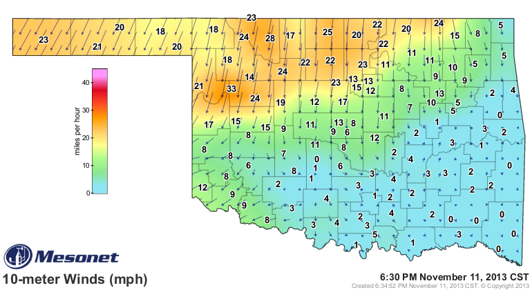
The top Mesonet map to the right shows the current temperatures across the state, snapshotted at 6:30 PM CST, with the strong gradient in northwest Oklahoma indicating the location of the cold front. (Please click here for the most updated version of the map.) Areas in northwest Oklahoma and the panhandle have seen a 3-hour temperature change ranging from about 15 to 30 degrees, as temperatures in the 50s and 60s quickly turned into the 30s and 40s this afternoon and evening. The front will continue to push southward into the rest of the state through the evening and overnight hours. With strong northerly winds behind the front, fueling the arctic air in to the region, expect even lower wind chill values. These strong northerly winds can be seen on the bottom Mesonet map to the right (again snapshotted at 6:30 PM), sustained at anywhere between about 20 and 35 mph. Across the rest of the state, winds are generally light and variable. You can click here for the most updated version of the wind gradient map.


 The timing of the front and colder air is shown in the first two graphics to the right, provided by the National Weather Service in Norman, OK. Obviously, the front is already invading the panhandle and northwest Oklahoma as mentioned above. By midnight, the front should have passed through most of the state except for the extreme southern portion of the state. Rain, mainly in the form of drizzle, can be expected from the front. There is a slight chance for wintry precipitation, primarily freezing drizzle, if temperatures drop below freezing. Again, strong northerly winds will also occur behind the front, and this will keep temperatures well below normal for the next few days, with exceptionally cold temperatures throughout the day tomorrow and Wednesday.
For Tuesday morning, a FREEZE WARNING is in effect across northern Oklahoma for temperatures dropping to the lower 30s. Tuesday's afternoon temperatures, which may not be the true "maximum" temperatures of the day depending on when the cold front arrives for your area, will be quite cold, only reaching the low-to-mid-40s at best. The graphic to the right is depicting the temperatures in the afternoon. The strong northerly winds will create wind chill values running between 5 to 10 degrees below the actual temperature. Therefore, we urge you to find that winter gear in your closet and utilize it. The "good" news is that skies will clear pretty quickly after the front passes through, so for most areas of the state, Tuesday should be mostly sunny, with areas in extreme southern Oklahoma seeing clearing skies in the afternoon and evening.
The big story from this cold front will be very cold, sub-freezing temperatures on Tuesday night in Wednesday morning. These forecasted cold temperatures, which will fall to the upper-teens to lower-20s, are the result of clear skies and calm winds that will occur during the mentioned time frame. As these frigid temperatures will be abnormally cold and kill sensitive crops, plants, and vegetation, a HARD FREEZE WARNING is in effect for a vast majority of the state from Tuesday evening to Wednesday morning. Though the hard freeze warning does not include the panhandle, as the growing season has ended in this region, temperatures will still drop to the mid-20s on Wednesday morning.
Wednesday afternoon will bring temperatures about 10 degrees warmer than on Tuesday with winds shifting from northerly to southerly. However, afternoon highs will still be well below average. Light winds will increase to 15 to 25 mph in the afternoon, with higher gusts possible, so wind chills will still occur. Skies will, however, remain sunny. Temperatures will slowly begin to rebound by the weekend, but chances for rain are in the forecast across parts of the state through next Monday. We will have more updates on this later.
AC
Sources: NWS, Mesonet, HOOT (NAM model display)
No comments:
Post a Comment