

 For Friday, get ready for the warmest temperatures we have seen so far this year. We’ll start of the day with morning lows in the mid-40s to low-50s across most of state, with the low-40s invading the panhandle. By the afternoon, temperatures will warm-up to the 80s across all regions of Oklahoma except the southeast, which will see those highs top out in the upper-70s. Skies will be clear to partly cloudy. Southerly winds will fuel the warm highs, so we do have an elevated risk of fire danger. Despite the recent rains, the ground still remains very dry. Winds will be from the south to southwest, blowing at 10 to 15 mph, gusting as high as 25 mph. Higher wind speeds, between 15 and 20 mph, with gusts at up to 35 mph are possible in northeast Oklahoma.
  As we head overnight Friday into Saturday morning, cloud cover increases in northern Oklahoma while skies remain mostly clear in central and southern Oklahoma. Low temperatures will remain above average. The low-to-mid-50s will stretch across central and eastern Oklahoma while the upper-40s stretch across the west, except for the panhandle, which will have the low-40s. On Saturday, the cooler air starts to invade northern Oklahoma. 80s on Friday will turn into 60s Saturday. Temperatures will be coolest over the panhandle, with highs in the low-60s. In contrast, the rest of northern Oklahoma will see the mid-to-upper-60s for highs. In central and southern Oklahoma, though the 80s disappear, the warm weather remains with highs in the 70s. The highs will be warmest in far southern Oklahoma, reaching the upper-70s.
 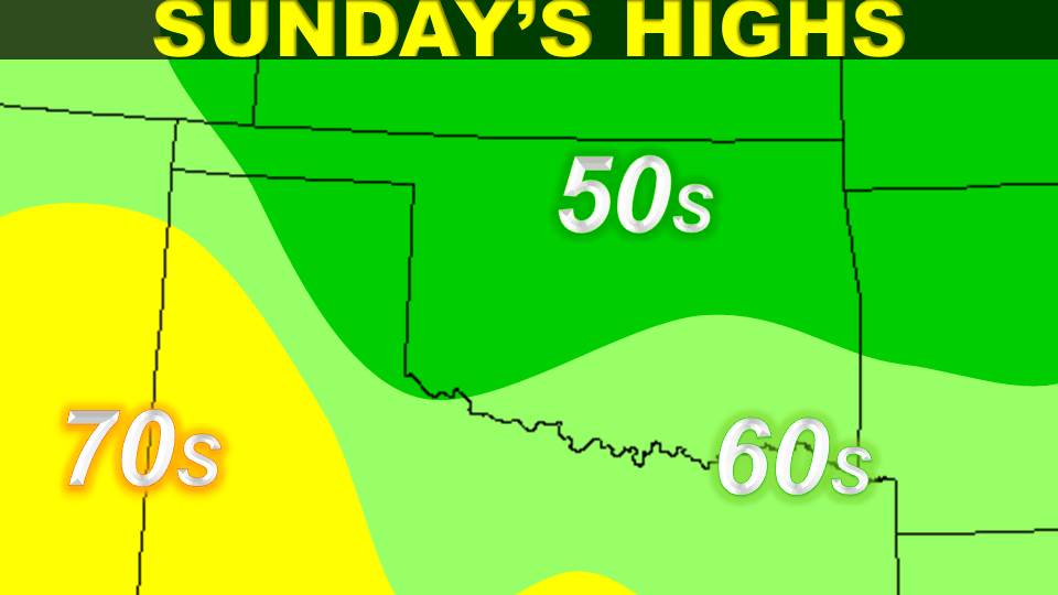 Saturday night into Sunday brings an entirely different story. An approaching low pressure system will bring a cold front and increased rain chances to central and northern Oklahoma, including the panhandle. Low temperatures will drop to the mid-30s in the panhandle and low-40s in the rest of northern Oklahoma. In central Oklahoma, lows will be in the mid-to-upper-40s. Then, for the remainder of the day on Sunday, highs will not top out above the 50s across central and northern Oklahoma. Depending on the exact track of this low, rain chances may increase and highs may be much colder, possibly not breaking out of the 40s. So keep your eye on the forecast. For southern Oklahoma, lows for Saturday night into Sunday will drop to the upper-40s for the southwest but remain in the 50s, up to the mid-50s, in south central and southeast Oklahoma. Highs across the south on Sunday will reach the 60s. Rain chances are possible all across the state, with the possibility of thunderstorms in the south.
 Previewing the new work week, although we know some of you may be on spring break, expect the cooler weather to remain through Tuesday. Then a steady warm-up comes by mid-week and continues until the end of the week. Rain chances will be over by Monday night across all of the state, and skies will clear up and remain that way for the rest of the week.
From all of us here at the Oklahoma Weather Lab, we wish you a safe and happy spring break. Safe travels for those of you leaving the state. We wish you a pleasant vacation and safe return. For those of you remaining in the state, let us recap: expect warm temperatures through Friday and Saturday before a brief taste of winter comes by the latter half of the weekend and into early next week. However, the warm-up comes just in time for spring to officially start on Wednesday.
Sources: NWS, HOOT, Mesonet
No comments:
Post a Comment